"The fact is," said Rabbit, "we've missed our way somehow."
|
|
|
|
| GET ON I-93 NORTH |
|
|
| TAKE I-93 NORTH TO NEW HAMPSHIRE |
|
N42°44.604',
W71°12.540' |
| CONTINUE ON I-93 NORTH TO JUNCTION OF ROUTE I-89 |
|
N43°10.230',
W71°31.770' |
| TAKE I-89 NORTH TO VERMONT |
|
N43°38.103',
W72°19.762' |
| CONTINUE ON 89 NORTH TO VERMONT EXIT 3 |
|
N43°49.656',
W72°34.807' |
| AT THE BOTTOM OF THE EXIT A LEFT ON RT. 107 EAST |
|
N43°49.621',
W72°34.662' |
| AT EATON'SUGAR HOUSE A RIGHT ONTO RT. 14 SOUTH |
|
N43°49.613,
W72°34.002 |
| IMMEDIATELY AFTER THE FOX STAND INN (ON THE RIGHT) TAKE A RIGHT ON A SMALL ROAD |
|
N43°49.383,
W72°33.865' |
| CONTINUE STRAIGHT ON THIS ROAD OVER A BRIDGE. | ||
| AFTER THE BRIDGE AT THE END OF THE ROAD, TAKE A LEFT AT THE T ONTO ROYALTON HILL RD. |
|
N43°49.361',
W72°34.021' |
| FOLLOW ROYALTON HILL ROAD TO THE FIRST MAJOR INTERSECTION (WITH JOHNSON HILL RD). |
|
|
| TAKE A LEFT AT THE INTERSECTION (FOUR CORNERS) ONTO JOHNSON HILL RD |
|
N43°46.795', W72°35.134' |
| FOLLOW JOHNSON HILL ROAD TO FISHER ROAD, A VERY SHARP RIGHT MARKED WITH A WHITE SIGN FOR "THE HUNDRED AKER WOOD" |
|
N43°46.949', W72°33.449' |
| TAKE A VERY SHARP RIGHT ON FISHER RD (AT THE "HUNDRED AKER WOOD" SIGN) |
|
|
| ABOUT TWENTY YARDS UP THE ROAD THERE IS A DRIVEWAY TO A HOUSE ON THE RIGHT. STAY LEFT. |
|
|
| A FEW YARDS BEYOND THE DRIVEWAY THE ROAD CURVES TO THE RIGHT AND THERE IS A ROAD BEARING LEFT. STAY RIGHT. |
|
|
| THIRTY YARDS BEYOND THIS IS A TURNAROUND AND TWO DRIVEWAYS. YOU CAN PARK IN THE TURNAROUND |
|
N43°46.410', W72°32.915' |
|
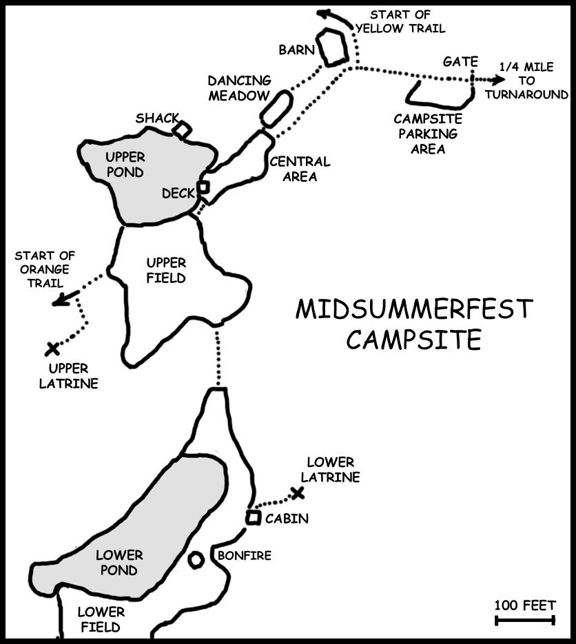
Take the leftmost, of the 3 forks (look for the Pooh's Place sign) to the campsite. Stay to the left at all forks until you reach the campsite. You have reached the campsite when you pass through a metal gate. Park immediately after passing through the 2nd gate. The Barn should be visible directly ahead. IMPORTANT: The road to the campsite is difficult. It is very rutted and it mostly uphill . Also, it is possible that branches may be in the road and trees may scratch your car. If you do decide to drive in to the campsite, your best bet is to stay out of the ruts. Get a running start and keep your momentum going. Please be careful not to spin your wheels, it tears up the road and causes further erosion. If you lose traction, back up and try again. Good clearance and four-wheel-drive help . The trickiness of driving in is compounded by wet ground and darkness. Be careful! I take no responsibility for damage to your car if you try to drive in. However, recent increased traffic on the road into the campsite has made it more passable than in years past. Most people attending MSF do drive all the way into the campsite. TNCers may drive all the way down to the hill to the Cabin (unless it is or has been raining) but should move their cars to the Parking Area by Friday afternoon. All other Festers should park in the parking area, though if it is raining, they may drive down to the Barn to unload their gear into the ground floor before parking. Watch out for the Standing Stone!
|
||